
Tianheban Fm
Type Locality and Naming
The type section of Tianheban Formation is the Tianheban section, lying on the south bank of Yangtze River, close to Shipai Village, about 16 km northwest of the seat of Yichang City (111°09’08” E, 30°46’23” N). The section was remeasured by Zhang (1978). In the type section, the formation is 99.25 m thick. The Tianheban Formation was named by Zhang et al. (1957). The name is derived from Tianheban in Sandouping Township, Yiling Distract, Yichang City, western Hubei Province. Originally it was called Tianheban Limestone by Zhang et al. (1957), and subsequently was renamed Tianheban Formation by Lu (1962).
Synonym: (天河板组)
Lithology and Thickness
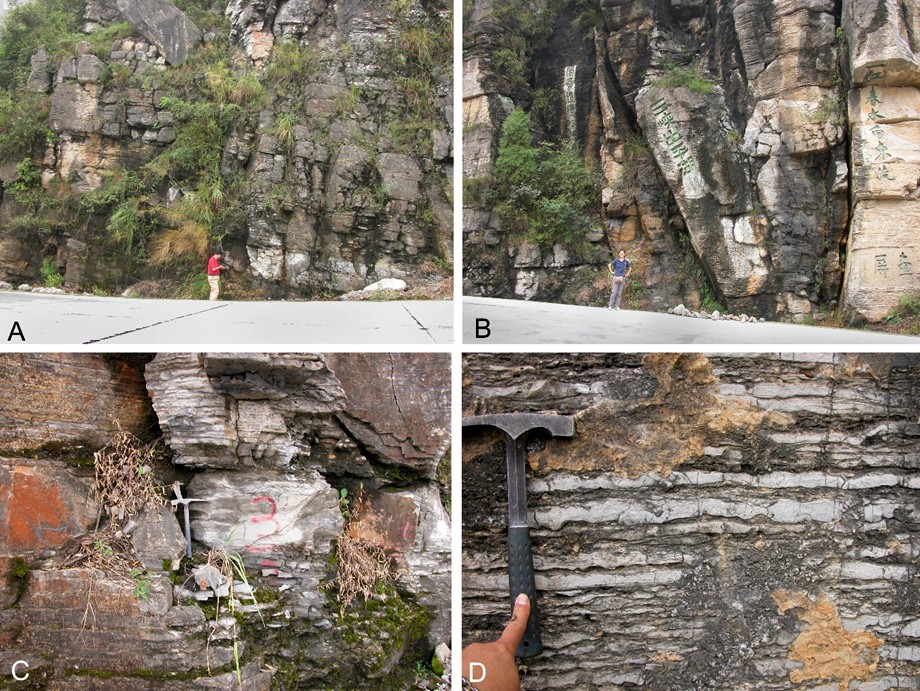
The Tianheban Formation is principally a carbonate sequence, composing of dark grey to grey, thin-bedded argillaceous striped limestone, interbedded with oolitic limestone and minor thin layers of yellowish green shale. The formation is characterized by containing rich archaeocyathids and trilobites.
[Figure: Outcrop and close-up views of the Tianheban Formation on the Yichang-Liantuo highway side, near Tianheban Village in the Yangtze Gorge area, Yiling District, Yichang, western Hubei Province, South China. A, B, lower and upper parts of the Tianheban Formation respectively; C, D, close-up views in basal and middle part of the formation.]
Relationships and Distribution
Lower contact
The Tianheban Fm is in conformable contact with the underlying Shipai Fm. The lower boundary is placed between the greyish green sandy shale of the underlying Shipai Fm and medium and thick-bedded fine-grained limestone of Tianheban Fm.
Upper contact
The Tianheban Fm is in conformable contact with the overlying Shihlungtong Fm. The upper boundary is placed between the thin-bedded, striped argillaceous limestone at the top of the Tianheban Fm and the thick-bedded dolomite of the overlying Shihlungtong Fm. The Formation is stable in lithology except for its upper part in the area of Xianfeng County, southwestern Hubei Province, where is consists of silty shale and sandy shale.
Regional extent
The Tianheban Formation is exposed in the Yangtze Area of South China Region, distributed in western, southwestern, and southeastern Hubei Province (Yichang, Xiangyan, and Xianning cities and Enshi Tujia and Miao Autonomous Prefecture) and northwestern corner of Hunan Province (Longshan County of Xiangxi Tujia and Miao Autonomous Prefecture). The formation varies greatly in thickness between 10.01 and 377 m.
GeoJSON
Fossils
The archaeocyathids from the Tianheban Formation belong to class Taenioidea, including Archaeocyathus hupehensis, A. yichangensis, Protopharetra sp., Retecyathus communis, R. kusmini, Sanciacyathus hubeiensis, and S. typus. Trilobites from the formation include Kootenia ziguiensis, Palaeolenus deprati, P. obsoletus, P. minor, Redlichia sp., Xilingxia convexa, X. ichangensis etc. Tianheban Formation contains only one horizon of archaeocyathids in most areas, but at Dahongchang, Fangxian County, northwestern Hubei Province, the formation bears two archaeocyathid horizons.
Age
Depositional setting
It is formed under the shallow-water and low-energy environment.
Additional Information